CyberSWIFT

Solutions With Innovative Future Technology

CyberSWIFT
  • challenges in monitoring road infrastructure and gis based solutions
    RCMS

    Challenges in Monitoring Road Infrastructure and GIS-Based Solutions

    6th March 2025 / 0 Comments

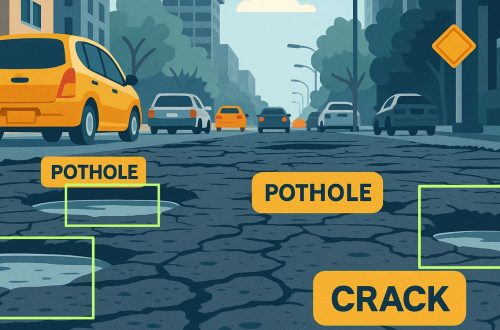
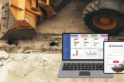
    Road infrastructure is the backbone of a country’s economy, facilitating trade, transportation, and connectivity. However, maintaining and monitoring road conditions is a complex task due to various challenges such as wear and tear, weather conditions, increasing vehicular load, and lack of real-time data. Traditional road monitoring methods often rely on manual inspections, which are time-consuming, expensive, and prone to errors. The integration of Geographic Information Systems (GIS) into road infrastructure monitoring provides a more efficient, accurate, and cost-effective solution. AI-based Road Condition Monitoring Systems leverage advanced machine learning algorithms and computer vision to detect road damages such as potholes, cracks, and surface degradation in real-time. These systems enhance efficiency by automating…

    read more
    Avik Bhattacharya

    You May Also Like

    rcms road condition monitoring system efficiency with ai-powered solutions

    Road Condition Monitoring System(RCMS): Enhancing Efficiency with AI-Powered Solutions

    17th December 2024
    a gis-based approach to road condition monitoring and pothole detection using ai

    A GIS-Based Approach to Road Condition Monitoring and Pothole Detection using AI

    31st July 2025

Back to site

RECENT POSTS

  • ensuring compliance when acquiring land & handling land litigation casesEnsuring Compliance When Acquiring Land & Handling Land Litigation Cases
  • a gis-based approach to road condition monitoring and pothole detection using aiA GIS-Based Approach to Road Condition Monitoring and Pothole Detection using AI
  • avoiding land disputes how to verify multiple claimants on a propertyAvoiding Land Disputes: How to Verify Multiple Claimants on a Property
  • using satellite imagery & survey data to confirm land locations how lams ensures accuracy and transparencyUsing Satellite Imagery & Survey Data to Confirm Land Locations: How LAMS Ensures Accuracy and Transparency

Categories

  • Artificial Intelligence
  • CSR
  • GIS
    • Disaster Management
  • Healthcare
  • Hoarding Management
  • LAMS
  • Land
  • Oil and Gas
  • Project Monitoring
  • RCMS
  • Remote Sensing
  • Retail
  • Salesforce
  • Telecom Utility
  • Uncategorised
    • Project Progress Monitoring System
  • Urban Development
  • Utility
  • Water Utility Solution
Copyright © 1997-2025 CyberSWIFT® Infotech Pvt. Ltd.
Ashe Theme by WP Royal.