Challenges in Monitoring Road Infrastructure and GIS-Based Solutions
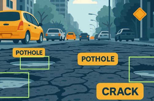
Road infrastructure is the backbone of a country’s economy, facilitating trade, transportation, and connectivity. However, maintaining and monitoring road conditions is a complex task due to various challenges such as wear and tear, weather conditions, increasing vehicular load, and lack of real-time data. Traditional road monitoring methods often rely on manual inspections, which are time-consuming, expensive, and prone to errors. The integration of Geographic Information Systems (GIS) into road infrastructure monitoring provides a more efficient, accurate, and cost-effective solution. AI-based Road Condition Monitoring Systems leverage advanced machine learning algorithms and computer vision to detect road damages such as potholes, cracks, and surface degradation in real-time. These systems enhance efficiency by automating data collection and analysis, ensuring timely maintenance and improved road safety.
This blog explores the key challenges in road infrastructure monitoring and how GIS-based solutions are revolutionizing this domain.
Challenges in Road Infrastructure Monitoring
1. Lack of Real-Time Data
One of the biggest challenges in road monitoring is the lack of real-time data on road conditions. Without up-to-date information, authorities struggle to make timely decisions regarding road maintenance and repairs, leading to worsening infrastructure issues.
2. Inefficient Traditional Inspection Methods
Manual road inspections require significant time and manpower. Inspectors must physically visit sites, document issues, and then report them—a process that can be both inaccurate and delayed. These methods often result in missed defects or inconsistencies in evaluation.
3. High Maintenance Costs
Regular maintenance of roads requires substantial financial resources. Without proper monitoring, funds may be misallocated, leading to inefficient repair work and frequent rework, increasing long-term costs.
4. Environmental and Weather Impact
Extreme weather conditions such as heavy rainfall, floods, or extreme heat can degrade roads quickly. Monitoring such damages and predicting their impact requires advanced technology and predictive analytics.
5. Traffic Congestion and Safety Issues
Poor road conditions can lead to traffic congestion, accidents, and vehicle damage. Without an efficient monitoring system, authorities cannot quickly identify and address these issues, posing risks to commuters.
6. Data Fragmentation and Lack of Centralized Monitoring
Different agencies may collect road data using various methods, leading to inconsistencies and fragmentation. A lack of centralized data storage and analysis makes it difficult to track infrastructure performance over time.
AI and GIS-Based Solutions for Road Monitoring
AI-based Road Condition Monitoring Systems complement GIS technology by providing real-time, automated road assessments using machine learning and computer vision. These systems detect cracks, potholes, and surface deterioration with high precision, enabling proactive maintenance and reducing long-term repair costs. By integrating AI-driven insights with GIS mapping, authorities can visualize road conditions, prioritize repairs, and optimize infrastructure management efficiently:
1. Real-Time Data Collection and Analysis
GIS-based systems integrate with IoT sensors, drones, and mobile applications to collect real-time road condition data. This data can be processed and analyzed instantly to provide actionable insights for maintenance planning.
2. Automated Road Surface Analysis
Advanced GIS tools use satellite imagery, LiDAR technology, and computer vision to detect cracks, potholes, and road deterioration. This automation reduces the reliance on manual inspections and enhances accuracy.
3. Predictive Maintenance with AI & GIS Integration
GIS-powered predictive analytics can assess historical road data and forecast potential damage. AI-driven models help prioritize repair schedules and allocate resources efficiently, reducing long-term maintenance costs.
4. Centralized Data Management
GIS platforms provide a centralized database where road condition data is stored and managed efficiently. Authorities can access historical records, analyze trends, and coordinate infrastructure projects seamlessly.
5. Improved Traffic and Safety Management
By overlaying real-time traffic data with road condition maps, GIS systems help identify accident-prone areas and suggest alternate routes. This minimizes congestion and enhances road safety for commuters.
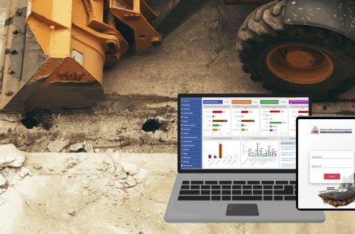
Road Condition Monitoring System (RCMS)
CyberSWIFT has developed an advanced Road Condition Monitoring System (RCMS) that leverages GIS and AI-powered analytics to offer a comprehensive road monitoring solution. Here’s how RCMS is transforming road infrastructure monitoring:
1. GIS Based Road Condition Assessment
RCMS uses GIS, Remote sensing and LiDAR technology to detect potholes, cracks, and surface damage automatically. This significantly reduces human error and ensures accurate condition assessment.
2. Mobile & IoT Integration
RCMS integrates with mobile apps and IoT-enabled devices to collect real-time road condition data. Field survey teams can use GPS-enabled mobile apps to upload images and reports directly into the system.
3. GIS-Based Mapping & Visualization
The system offers an interactive GIS-based dashboard where road conditions are mapped in real-time. Authorities can visualize damage severity, prioritize maintenance tasks, and track project progress efficiently.
4. Predictive Analytics for Smart Maintenance
RCMS incorporates predictive analytics to estimate road deterioration trends. This helps stakeholders in planning long-term maintenance strategies and optimizing budget allocation.
5. Cloud-Based Data Storage & Accessibility
RCMS provides cloud-based data storage, ensuring all stakeholders—government agencies, road authorities, and maintenance teams—can access critical data from anywhere, improving decision-making efficiency.
Conclusion
Monitoring and maintaining road infrastructure is crucial for a country’s development, but traditional methods pose significant challenges. GIS-based solutions, such as Road Condition Monitoring System (RCMS), provide a smarter, more efficient way to address these challenges. By integrating GIS, IoT, and predictive analytics, RCMS helps authorities gain real-time insights, improve road safety, and optimize maintenance costs.
As the world moves towards smart cities and digital infrastructure management, leveraging GIS technology for road condition monitoring is no longer optional—it’s essential. CyberSWIFT‘s RCMS is at the forefront of this transformation, ensuring better roads, safer travel, and smarter urban planning.

He is a business development professional with 10+ years of experience in Sales, Pre-Sales, Market Research, Concept Selling, Business Development, and Account Management. Skilled in managing end-to-end sales processes, including lead generation, pre-sales, account management, post-sales, and customer support. Holds an MCA degree.
Currently leading the Urban Development vertical at CyberSWIFT Infotech, with key responsibilities that include:
Managing business operations across India, Overseeing and mentoring teams to achieve targets, Identifying and exploring new application areas and growth opportunities.
Avik Bhattacharya
He is a business development professional with 10+ years of experience in Sales, Pre-Sales, Market Research, Concept Selling, Business Development, and Account Management. Skilled in managing end-to-end sales processes, including lead generation, pre-sales, account management, post-sales, and customer support. Holds an MCA degree. Currently leading the Urban Development vertical at CyberSWIFT Infotech, with key responsibilities that include: Managing business operations across India, Overseeing and mentoring teams to achieve targets, Identifying and exploring new application areas and growth opportunities.


You May Also Like

AI Based Road Condition Monitoring System: Transforming Infrastructure Management
A GIS-Based Approach to Road Condition Monitoring and Pothole Detection using AI