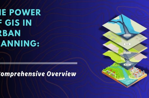
Urban Development Property Survey & Mapping: Powering Smart Cities with Precision
As cities continue to grow rapidly, efficient property administration and urban planning have become more crucial than ever. A property survey and mapping system acts as the foundation for sustainable urban development, facilitating everything from infrastructure planning to legal property ownership. By integrating cutting-edge technologies like Geographic Information Systems (GIS), Unmanned Aerial Vehicles (UAVs), and centralized digital property databases, municipalities and private developers can ensure accurate, transparent, and accessible property records.
Let’s explore how this process works, why it’s essential, and how it’s shaping the future of smart cities.
Why Property Survey & Mapping is Essential in Urban Development
Inaccurate property boundaries, outdated property records, and unchecked encroachments have long hindered efficient city planning. Traditional surveying methods were time-consuming, prone to errors, and often disconnected from evolving urban landscapes. Modern property survey and mapping techniques solve these issues with speed and accuracy.
Key Objectives of Property Survey & Mapping
Accurate Property Information
Establishing a detailed and verifiable record of property boundaries, ownership status, and land use.
Regulatory Compliance
Ensuring all property development aligns with local zoning laws and municipal regulations.
Revenue Optimization
Improving the accuracy of property tax assessments and enhancing municipal revenue collection.
Infrastructure & Urban Planning
Supporting projects like road expansion, drainage networks, utility lines, and green space development.
Encroachment Detection & Prevention
Identifying illegal constructions and taking prompt action to maintain urban order.
Key Components of an Effective Property Survey & Mapping System
1. Geospatial Data Collection
The first and most critical step involves collecting precise data:
- UAV (Drone) Mapping: Captures high-resolution aerial imagery for large areas in a short time.
- GPS-Based Surveys: Enables pinpoint accuracy for ground-level property measurements.
- GIS Tagging: Geospatially links property features with coordinate-based data for seamless mapping.
2. Digital Property Database Creation
A centralized digital repository forms the backbone of modern property records. It typically includes:
- GIS-linked maps and ownership information
- Land use classification and property dimensions
- Taxation history and payment status
- Access controls for municipal staff, surveyors, and even the public
3. Boundary Demarcation & Legal Documentation
Using geospatial tools, officials can:
- Precisely mark and record property extents
- Cross-reference digital maps with existing legal documents
- Settle disputes using clear, legally documented boundary evidence
4. Automated Taxation & Revenue Collection
Smart municipalities now integrate survey data into revenue systems:
- Auto-assessment of property values
- Digital tax calculations based on updated records
- Automated tax alerts and reminders for property owners
Implementation Approach: From Planning to Execution
Successfully executing a property survey and mapping initiative requires a strategic, phased approach:
1. Survey Planning & Data Acquisition
Leverage UAVs and GPS equipment to collect accurate, up-to-date data from the ground and air.
2. GIS Mapping & Database Development
Convert raw survey data into GIS layers, link them with property records, and build a unified property information system.
3. Regulatory Framework Alignment
Ensure all collected and processed data complies with regional and national land regulations.
4. System Deployment & Training
Train municipal employees, surveyors, and administrators to use the system effectively for daily operations.
5. Continuous Monitoring & Updates
Conduct periodic surveys using drones and ensure regular updates to the property database for long-term reliability.
Major Benefits of Property Survey & Mapping in Urban Governance
Enhanced Accuracy
Reduces administrative errors and legal disputes by providing reliable data on ownership and property boundaries.
Transparency & Public Access
Digital maps and records foster trust and enable better citizen engagement with governance processes.
Revenue Growth for Municipalities
Accurate property taxation leads to better financial planning and infrastructure development.
Smart & Sustainable Urban Planning
With a clear view of land use patterns, city planners can implement zoning policies and infrastructure projects with efficiency.
Conclusion: A Smarter Future Through Digital Property Mapping
The integration of property survey and mapping technologies is not just a modernization of property records—it’s a complete transformation in how cities grow and function. By combining GIS, UAV-based mapping, and centralized digital databases, municipalities can usher in an era of transparent governance, improved public services, and smarter urban development.
Investing in such systems today means laying the groundwork for more resilient, inclusive, and well-managed cities tomorrow.
Ready to Digitize Your City’s Property Records?
Whether you’re a municipality, developer, or property stakeholder, modern property survey and mapping solutions can simplify complex challenges. Contact us today to learn how GIS-based property survey systems can transform your urban landscape.

He is a business development professional with 10+ years of experience in Sales, Pre-Sales, Market Research, Concept Selling, Business Development, and Account Management. Skilled in managing end-to-end sales processes, including lead generation, pre-sales, account management, post-sales, and customer support. Holds an MCA degree.
Currently leading the Urban Development vertical at CyberSWIFT Infotech, with key responsibilities that include:
Managing business operations across India, Overseeing and mentoring teams to achieve targets, Identifying and exploring new application areas and growth opportunities.


