GIS Property Mapping Survey and QR-Based UID System for Municipal Governance: A Complete Digital Transformation Framework
Urban local bodies across India and many developing regions are facing increasing pressure to modernize property administration, improve tax collection efficiency, and build transparent governance systems. Traditional municipal property management methods — often dependent on outdated records, paper-based surveys, and fragmented databases — are no longer capable of supporting rapidly growing urban environments.
To address these challenges, modern municipalities are adopting GIS-based property mapping systems integrated with QR-enabled digital property identification. These technologies help local governments establish accurate property databases, streamline taxation processes, improve urban planning, and enhance citizen services.
This blog explores how a comprehensive GIS Property Mapping Survey and QR-Based Unique Property Identification System can transform municipal governance through geospatial intelligence, digital infrastructure, and real-time property management.
The Growing Need for Digital Municipal Property Management
Municipal corporations are responsible for maintaining accurate property records, assessing taxes, monitoring urban growth, and supporting infrastructure planning. However, many municipal systems still operate using legacy records that are incomplete, inconsistent, or outdated.
Common problems faced by municipalities include:
- Unauthorized and unmapped properties
- Duplicate or inaccurate tax records
- Revenue leakage from unassessed properties
- Lack of centralized GIS-enabled databases
- Delayed citizen services
- Difficulty in field verification of properties
- Manual survey errors and operational inefficiencies
- Poor visibility into urban expansion and infrastructure needs
As cities expand rapidly, these issues become increasingly difficult to manage without a modern geospatial framework.
This is where GIS-based municipal property mapping becomes essential.
What is GIS-Based Property Mapping?
GIS (Geographic Information System) property mapping is a technology-driven approach that digitally captures, maps, and manages all municipal properties within a centralized geospatial platform.
The system combines:
- Spatial mapping
- Property ownership records
- Tax assessment data
- Satellite imagery
- LiDAR surveys
- Geo-tagged field data
- QR-based property identification
The result is a highly accurate, searchable, and scalable digital property ecosystem that supports smarter municipal administration.
Core Objectives of the GIS Property Mapping Project
The primary objective of the project is to modernize municipal governance using digital geospatial infrastructure.
Key objectives include:

1. Modernization of Municipal Property Records
Digitizing legacy records and integrating them into a centralized GIS system improves data accessibility, transparency, and operational efficiency.
2. Accurate Property Tax Assessment
GIS-enabled property mapping helps identify unassessed properties, remove duplicate records, and ensure fair tax calculation.
3. Unique Digital Identification of Properties
QR-based UID cards provide every property with a unique digital identity for quick verification and record retrieval.
4. Improved Urban Planning
Spatial data helps municipalities monitor urban growth, infrastructure demand, zoning compliance, and land utilization patterns.
5. Strengthening Smart Governance
The project creates a future-ready digital foundation that supports smart city initiatives, digital governance, and data-driven decision-making.
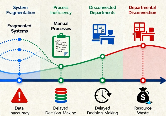
Key Challenges Faced Before GIS Implementation
Before implementation of GIS property mapping systems, municipal corporations often face several operational and governance challenges.
Outdated GIS and Property Records
Older property surveys are frequently inaccurate or incomplete due to urban expansion, unauthorized construction, and changing ownership patterns.
Revenue Leakage
Properties that remain unmapped or incorrectly classified contribute to substantial revenue losses in property taxation systems.
Lack of Centralized Data
Different municipal departments often maintain disconnected databases, making property verification and planning difficult.
Manual Survey Processes
Paper-based surveys are time-consuming and prone to human error, resulting in inconsistent records and delayed processing.
Difficulty in Dense Urban Mapping
Walled city regions and densely populated urban areas create significant challenges for conventional surveying methods.
Slow Citizen Services
Without digital access to records, municipalities struggle to provide quick approvals, verification services, and tax-related support.
Major Components of the GIS Property Mapping Solution
A successful municipal GIS property mapping initiative involves multiple integrated technological components.
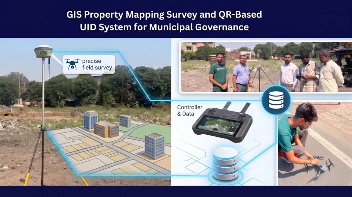
1. LiDAR-Based Aerial Survey and High-Resolution Imagery
LiDAR (Light Detection and Ranging) technology enables municipalities to capture highly accurate spatial information through aerial scanning.
Benefits include:

- Precise building footprint extraction
- Elevation and terrain modeling
- Accurate road and infrastructure mapping
- Improved spatial accuracy in dense urban regions
- Faster base map preparation
Combined with high-resolution aerial imagery, LiDAR creates a reliable geospatial foundation for municipal GIS databases.
2. GIS Base Map Creation
The GIS base map serves as the digital backbone of the municipal property management system.
It includes:
- Property boundaries
- Road networks
- Administrative boundaries
- Utility layers
- Infrastructure assets
- Land-use information
A properly designed GIS base map supports multiple municipal operations beyond taxation, including infrastructure planning and urban development monitoring.
3. DGPS and Mobile GIS-Based Field Surveys
Differential GPS (DGPS) and mobile GIS technologies are used for field-level verification and geo-referenced data collection.
Field teams capture:
- Property coordinates
- Ownership details
- Usage classification
- Occupancy status
- Tax-related information
- Property photographs
- Geo-tagged validation data
Mobile GIS applications ensure real-time synchronization of field data into the central GIS platform.
4. Door-to-Door Property Survey and Geo-Tagging
Door-to-door surveys remain critical for collecting detailed municipal assessment information directly from property owners.
Survey teams gather:
- Owner details
- Property usage
- Built-up area
- Tax assessment parameters
- Occupancy information
- Commercial or residential classification


Each property is geo-tagged to ensure spatial accuracy and eliminate duplication.
5. QR-Based Unique Property ID Generation
One of the most impactful innovations in the system is QR-based UID generation.
Each property receives a unique QR-enabled digital identity card linked to the GIS database.
Benefits of QR-Based Property IDs
- Instant property verification
- Faster tax assessment
- Simplified field inspections
- Easy access to digital records
- Reduced duplication and fraud
- Improved citizen service delivery
Municipal staff can simply scan the QR code to retrieve property information instantly from the GIS platform.
6. GIS Database Integration
A centralized GIS database integrates:
- Legacy municipal records
- Taxation data
- Survey information
- Spatial datasets
- Ownership records
- Field verification data
This integration creates a unified municipal data ecosystem that supports multiple governance functions.
7. Web GIS Platform Development
A Web GIS platform enables municipal officials to visualize and manage property information through an interactive digital interface.
Key capabilities include:
- Property search
- Spatial visualization
- Layer management
- Tax monitoring
- GIS analytics
- Urban planning support
- Real-time property tracking
Web GIS systems provide centralized access to municipal data across departments.
8. Mobile Data Collection Application
Mobile GIS applications allow field surveyors to collect and validate property data directly from the field.
Features include:
- Real-time synchronization
- GPS-enabled data capture
- Geo-tagged images
- Offline data collection support
- Instant validation workflows
- Field activity monitoring
These applications significantly improve operational efficiency and data accuracy.
9. Spatial Validation and Quality Assurance
Spatial validation mechanisms ensure the integrity and reliability of GIS property databases.
Quality assurance includes:
- Duplicate property detection
- Spatial accuracy checks
- Boundary validation
- Data standardization
- Error correction workflows
- Verification audits
Strong QA processes are essential for maintaining long-term database accuracy.
10. Decision Support Dashboard
Advanced GIS dashboards provide municipalities with real-time insights into urban administration.
Dashboards help track:
- Tax revenue trends
- Property distribution
- Urban growth patterns
- Infrastructure demand
- Survey progress
- Field operations
- Revenue leakage areas
These insights support evidence-based planning and governance decisions.
Key Benefits of GIS-Based Municipal Property Mapping
Improved Property Tax Revenue
By identifying unmapped and under-assessed properties, municipalities can significantly increase tax collection efficiency and reduce revenue leakage.
Faster Property Verification
QR-enabled property identification simplifies verification during field inspections and citizen service operations.
Better Urban Governance
Centralized GIS systems improve transparency, monitoring, and interdepartmental coordination.
Enhanced Citizen Services
Digital property records allow faster service delivery for tax payments, property verification, certificates, and approvals.
Accurate Urban Planning
GIS data supports smarter infrastructure planning, zoning analysis, and urban expansion management.
Reduced Manual Work
Automation reduces paperwork, operational delays, and dependency on manual processes.
Future-Ready Smart Governance
The digital GIS platform establishes the foundation for smart city initiatives and integrated municipal management systems.

Role of GIS in Smart Municipal Governance
Modern municipalities are increasingly adopting GIS as a core governance technology rather than just a mapping tool.
GIS supports:
- Smart city planning
- Infrastructure lifecycle management
- Asset monitoring
- Land administration
- Utility management
- Disaster response planning
- Environmental monitoring
- Revenue administration
A GIS-driven municipal ecosystem enables cities to become more data-centric, transparent, and citizen-focused.
Implementation Challenges and Considerations
While GIS property mapping projects offer substantial benefits, successful implementation requires careful planning.
Key considerations include:
Data Accuracy
High-quality field surveys and spatial validation are essential to maintain database reliability.
Interdepartmental Coordination
Multiple municipal departments must collaborate during integration and implementation.
Technology Infrastructure
Municipalities require scalable GIS infrastructure and secure data management systems.
Training and Capacity Building
Municipal teams must be trained to effectively operate GIS platforms and digital workflows.
Long-Term Database Maintenance
Regular updates and continuous verification processes are necessary to keep property databases current.
The Future of GIS-Based Municipal Administration
The future of municipal governance is increasingly driven by geospatial intelligence and digital infrastructure.
Emerging technologies such as:
- AI-powered GIS analytics
- Drone surveys
- Digital twins
- IoT-enabled urban monitoring
- Predictive urban planning
- Cloud GIS platforms
will further enhance municipal efficiency and smart governance capabilities.
GIS-based property mapping is no longer just a modernization initiative — it has become a strategic necessity for sustainable urban administration.
Conclusion
GIS Property Mapping Surveys integrated with QR-Based Unique Property Identification systems are transforming the way municipalities manage urban properties, taxation, and governance.
By combining LiDAR surveys, GIS mapping, mobile data collection, QR-enabled identification, and centralized digital databases, municipal corporations can significantly improve operational efficiency, revenue management, transparency, and citizen services.
As urbanization continues to accelerate, municipalities that invest in GIS-driven digital governance platforms will be better positioned to support sustainable development, smarter infrastructure planning, and future-ready city administration.
Organizations like CyberSWIFT are helping municipalities implement advanced GIS-based governance systems that enable scalable, accurate, and technology-driven urban management solutions.

He is a business development professional with 10+ years of experience in Sales, Pre-Sales, Market Research, Concept Selling, Business Development, and Account Management. Skilled in managing end-to-end sales processes, including lead generation, pre-sales, account management, post-sales, and customer support. Holds an MCA degree.
Currently leading the Urban Development vertical at CyberSWIFT Infotech, with key responsibilities that include:
Managing business operations across India, Overseeing and mentoring teams to achieve targets, Identifying and exploring new application areas and growth opportunities.
Avik Bhattacharya
He is a business development professional with 10+ years of experience in Sales, Pre-Sales, Market Research, Concept Selling, Business Development, and Account Management. Skilled in managing end-to-end sales processes, including lead generation, pre-sales, account management, post-sales, and customer support. Holds an MCA degree. Currently leading the Urban Development vertical at CyberSWIFT Infotech, with key responsibilities that include: Managing business operations across India, Overseeing and mentoring teams to achieve targets, Identifying and exploring new application areas and growth opportunities.

