A GIS-Based Approach to Road Condition Monitoring and Pothole Detection using AI
Maintaining road infrastructure is a critical responsibility for urban and rural authorities alike. Roads with potholes, cracks, and surface deterioration not only affect vehicle performance but also pose significant safety risks. A systematic and technology-enabled approach is essential for improving road conditions, optimizing road maintenance efforts, and ensuring timely project completion.
This is where AI-based road condition monitoring systems come into play. They provide spatial intelligence, visual analytics, and data-driven insights that can significantly improve how road infrastructure is built and maintained.
Understanding Road Condition Monitoring Systems
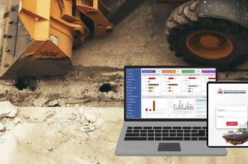
A road condition monitoring system is a comprehensive framework that continuously assesses the health of road infrastructure. It combines with field data to track road conditions in real time or at regular intervals.
Key functions of a road monitoring system include:
- Detecting potholes on roads
- Monitoring surface irregularities
- Broken road identifications
- Several cracks in the roads identification.
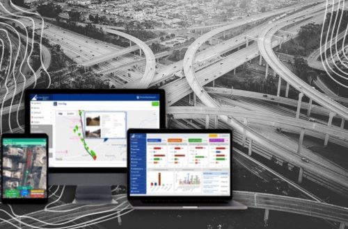
By utilizing GIS (Geographic Information Systems), these systems offer precise location-based intelligence, enabling stakeholders to make better decisions regarding repair, budgeting, and future planning.
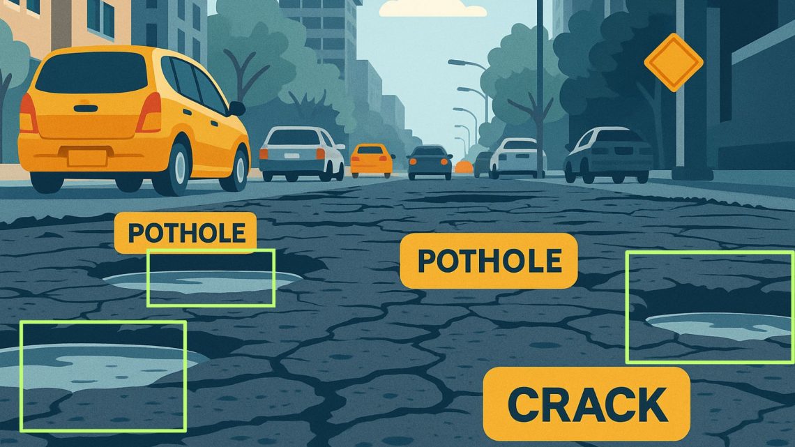
How GIS Detects Potholes and Road Defects
One of the major components of road condition monitoring is pothole, Subsidence & several cracks in the road detection. Through mobile video data are captured. These videos are processed through AI to identify:
- Potholes
- Subsidence
- Alligator Cracking
- Longitudinal Cracking
Applications in Real-World Scenarios
✅ Urban Road Networks
Municipal bodies can deploy GIS-based systems to track damage in congested city roads. Periodic road inspections can feed into the GIS platform to map areas with potholes & other defects on roads and develop localized repair schedules.
✅ Highway and Expressway Management
For national and state highways, GIS enables scalable monitoring across long stretches.
✅ Rural Roads and PMGSY Projects
Government initiatives like PMGSY (Pradhan Mantri Gram Sadak Yojana) can benefit from platforms to monitor, detect several road depressions in the remote area.
Advantages of Using AI in Road Condition Monitoring
- Accurate Visualization of Problem Areas: Map potholes, cracks, and erosion with GPS coordinates.
- Preventive Maintenance Strategy: Identify recurring trouble zones before damage escalates.
- Digital Asset Management: Maintain digital databases of roads.
- Improved Road Safety: Analyze traffic and environmental factors that contribute to deterioration and accidents.
Final Thoughts
From potholes in roads to digital road condition monitoring, GIS enables a comprehensive understanding of how roads behave under stress and how they can be preserved more efficiently. Investing in road surface monitoring systems backed by geospatial intelligence is not just a technological upgrade—it’s a step toward safer, smarter, and more sustainable roads.

He is a business development professional with 10+ years of experience in Sales, Pre-Sales, Market Research, Concept Selling, Business Development, and Account Management. Skilled in managing end-to-end sales processes, including lead generation, pre-sales, account management, post-sales, and customer support. Holds an MCA degree.
Currently leading the Urban Development vertical at CyberSWIFT Infotech, with key responsibilities that include:
Managing business operations across India, Overseeing and mentoring teams to achieve targets, Identifying and exploring new application areas and growth opportunities.
Avik Bhattacharya
He is a business development professional with 10+ years of experience in Sales, Pre-Sales, Market Research, Concept Selling, Business Development, and Account Management. Skilled in managing end-to-end sales processes, including lead generation, pre-sales, account management, post-sales, and customer support. Holds an MCA degree. Currently leading the Urban Development vertical at CyberSWIFT Infotech, with key responsibilities that include: Managing business operations across India, Overseeing and mentoring teams to achieve targets, Identifying and exploring new application areas and growth opportunities.


You May Also Like
Challenges in Monitoring Road Infrastructure and GIS-Based Solutions