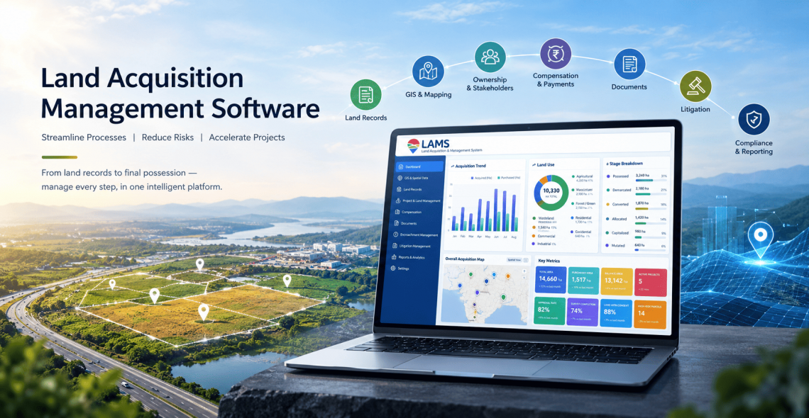
Land Acquisition Management Software 2026: Features, Workflow and How to Choose
Every large project, whether a mine, a solar park, a steel plant, a highway or an industrial estate, starts with land. And on most projects, land is where schedules slip first.
The cause is rarely one big failure. It’s hundreds of small ones: a survey number that doesn’t match the title, a landowner paid twice, a lease renewal that nobody tracked, a court date that lived in one person’s inbox. Each one is small, but together they delay possession, inflate costs and put compliance at risk.
Land acquisition management software exists to stop that. This guide explains what it is, what it should do, how a good workflow looks, and how to choose a system without buying something your team abandons in six months.
What is land acquisition management software?
Land acquisition management software is a system that tracks every parcel of land a project needs, from first identification to final possession and ongoing management. It brings land records, ownership details, maps, compensation, approvals, documents and disputes into one place that the whole team can see and trust.
It is different from a generic CRM or a shared spreadsheet in three ways:
- It understands land. It works with survey numbers, parcels, ownership chains, heirs, area units, and the sequence of statutory steps.
- It connects records to action. A parcel isn’t just a row. It has status, pending payments, linked documents, map location and history.
- It creates accountability. Every update is logged, every approval has an owner, and every deadline is visible.
Why spreadsheets and paper files stop working
Most teams begin with Excel, and for a handful of parcels it’s fine. The problems show up at scale:
- Multiple versions. Five people hold five copies of the “latest” tracker, and nobody knows which is right.
- No link to maps or documents. A parcel’s sale deed, mutation record and payment proof sit in different folders, if they can be found at all.
- No audit trail. You can’t tell who changed an area or owner name, or when.
- Missed dates. Lease expiries, notice periods and hearing dates depend on someone remembering.
- Reporting takes days. When management asks “how much land do we hold and what is pending?”, the answer takes a week of manual consolidation.
- Knowledge walks out the door. When the person who understood the tracker leaves, so does the project’s land history.
If you recognize two or three of these, you’ve likely outgrown spreadsheets.
Core features to look for
Not every project needs every feature, but these are the building blocks of a capable system.
1. Centralized land records
A single database of every parcel with survey or plot number, area, location, land use, ownership details and history. Look for the ability to handle multiple owners, heirs, and changes in ownership over time.
2. GIS and parcel mapping
Seeing parcels on a map exposes problems that tables hide: gaps in a corridor, overlapping claims, and parcels that fall outside the project boundary. Map views should link back to each parcel’s record.
3. Document management
Every deed, notice, survey sheet, approval and payment proof should be attached to the parcel it belongs to, searchable, and version-controlled. This is what makes audits and due diligence manageable.
4. Compensation and payment tracking
Calculating compensation, tracking approvals, recording payments and flagging mismatches. For projects with rehabilitation and resettlement obligations, the system should track those entitlements alongside compensation.
5. Stakeholder and landowner management
A record of every landowner, tenant and claimant, with communication history, agreements, and outstanding issues. This is also where you manage grievances before they become disputes.
6. Workflow and approvals
Configurable stages with assigned owners, so each parcel moves through the process in a defined order and you can see exactly where it’s stuck.
7. Lease and encroachment management
Once land is acquired, the work continues. Look for lease terms, renewal alerts, escalation tracking, and tools to identify, document and resolve encroachment.
8. Litigation tracking
A central view of cases linked to parcels: court, stage, next hearing date, and responsible counsel. Disputes are one of the biggest sources of delay, and they’re easy to lose track of.
9. Dashboards and reporting
Real-time answers to the questions leadership asks: how many parcels are acquired, in progress or blocked, how much has been paid, and what’s pending.
10. Integration
The system should connect with your ERP and finance tools such as SAP or Oracle, so payments and records stay consistent without double entry.
A typical land acquisition workflow in software
Here is how the process looks when it’s managed in a single system:
- Identify and map parcels. Import the project footprint and parcel data, and map it.
- Verify records. Check title, ownership and area against source records, and flag discrepancies early.
- Engage landowners. Log notices, meetings and agreements against each owner.
- Calculate and approve compensation. Run calculations, route for approval, and record decisions.
- Pay and document. Record payments, attach proof, and update parcel status.
- Take possession. Mark parcels as acquired, with dates and supporting documents.
- Manage ongoing risk. Track leases, encroachments, and litigation after acquisition.
- Report. Give leadership and auditors a live view at any time.
The value isn’t any single step. It’s that every step happens in one place, with a record of who did what and when.
Who benefits most
- Mining and steel companies managing large, contiguous land holdings with long-term leases and compliance obligations
- Solar and renewable developers assembling many leased parcels across multiple villages or districts
- Infrastructure and utility projects acquiring linear corridors for roads, rail, transmission or pipelines
- Industrial parks and real estate developers managing allotments, titles and approvals at scale
- Government and public authorities handling acquisition, compensation and records for public projects
How to choose land acquisition management software
Use this checklist when you evaluate vendors.
Fit for your process
- Does it match your statutory and approval workflow, or force you to change it?
- Can workflows be configured without custom development?
- Does it support the regions and regulations you operate in?
Data and migration
- How will your existing records be digitized and imported?
- Who cleans the data, and how are discrepancies handled?
- Can it handle your volume of parcels and documents?
Usability
- Can field teams, legal, finance and management all use it without heavy training?
- Is it accessible on mobile for site work?
Integration and security
- Does it integrate with your ERP and finance systems?
- What access controls and audit logs exist?
- Where is data hosted?
Implementation and support
- What does the first 90 days look like?
- Who supports you after go-live?
- Can they show a comparable project in your industry?
Cost
- What does pricing depend on: users, parcels, modules, hosting?
- What’s included in implementation, training and support?
Ask each vendor for a live demo using your sample data, not a polished sandbox. That’s the fastest way to see whether the system fits.
Common mistakes to avoid
- Buying features, not fit. A long feature list matters less than whether the workflow matches how your team works.
- Skipping data cleanup. Migrating messy records into a new system just moves the mess. Budget time to verify data first.
- No clear owner. Assign someone in the business, not only IT, to drive adoption.
- Trying to do everything at once. Start with records and the highest-risk parcels, then expand to modules like leases and litigation.
- Ignoring post-acquisition needs. Lease renewals and encroachment are where value leaks long after the land is acquired.
How LAMS helps
LAMS is a land acquisition and management platform built for project-driven industries. It brings land records, GIS, documents, compensation, leases, encroachment and litigation into one system, and integrates with enterprise tools such as SAP and Oracle.
LAMS is serving 60+ Companies with seamless land management managing 10,00,000+ Acres of land and 1 Million+ Documents.
Frequently asked questions
What is the difference between land acquisition software and land management software?
Land acquisition software focuses on the process of securing land: identifying parcels, verifying titles, negotiating, paying compensation and taking possession. Land management software covers the ongoing work afterward: leases, assets, encroachment, and records. Most project companies need both, which is why modern platforms combine them.
How long does implementation take?
It depends mainly on the state of your data and level of customization. A typical rollout takes around 3-4 months.
Can it handle records we only have on paper?
Yes, if the vendor offers digitization. Paper records are scanned, verified and structured before being loaded into the system. This is often the largest part of the project.
Does it work with our existing ERP?
Good systems integrate with common ERPs so payments and records stay in sync. Confirm your specific ERP and version during evaluation.

Darshana Mukherjee is a Senior Consultant in Business Development with over 11 years of experience in sales, primarily focused on the Geospatial IT industry. Her expertise lies in driving business growth through strategic partnerships, client engagement, and delivering solutions. She combines her technical knowledge with business acumen to contribute effectively to organizational success.
Darshana Mukherjee
Darshana Mukherjee is a Senior Consultant in Business Development with over 11 years of experience in sales, primarily focused on the Geospatial IT industry. Her expertise lies in driving business growth through strategic partnerships, client engagement, and delivering solutions. She combines her technical knowledge with business acumen to contribute effectively to organizational success.

You May Also Like
How to Cross-Check Land Boundaries with Government Records
How Ownership Transfers Over Time: Inheritance, Sales, Leases, and Beyond