Land Due Diligence in India: A Complete Guide (2026)
Land acquisition is a major investment for businesses, developers, infrastructure companies, and institutional investors. Whether for manufacturing, residential development, renewable energy, or industrial parks, project success depends heavily on the quality and legal status of the land.
Land transactions involve records and approvals maintained by different authorities. Ownership, revenue records, zoning, environmental restrictions, government notifications, mortgages, litigation, pending mutations, and land-use restrictions can create hidden risks, delays, and additional costs.
Land due diligence is therefore a comprehensive examination of legal ownership, financial obligations, regulatory compliance, physical characteristics, and spatial risks. It enables informed decisions before capital is committed and is increasingly supported by GIS and Land Acquisition & Management Systems (LAMS).
Understanding Land Due Diligence
Land due diligence is a structured investigation before purchasing or leasing land to determine whether it is legally, financially, physically, and commercially suitable for its intended purpose.
A registered sale deed confirms that a transaction occurred; it does not by itself establish undisputed, transferable title or confirm that the land can legally be developed for the intended use.
A comprehensive review covers ownership history, revenue records, mortgages and disputes, zoning and land-use permissions, government acquisition plans, environmental restrictions, and consistency between physical boundaries and official cadastral records. For large-scale acquisitions, it is a strategic risk-management exercise.
Why Land Due Diligence Has Become More Critical
Rapid growth in infrastructure, renewable energy, logistics, manufacturing, industrial corridors, and urban development has increased both land demand and transaction complexity. Revenue departments, registration offices, planning authorities, and environmental agencies maintain different records, so inconsistencies can occur.
Rising land values make acquisition mistakes more expensive. A disputed title or overlooked acquisition notification can delay a multi-crore project for months or years. Digital land records, satellite imagery, GIS platforms, and enterprise land-management solutions now enable organizations to combine legal verification with spatial intelligence.
Essential Pillars of Land Due Diligence
1. Legal Ownership and Chain of Title
Confirm that the seller has a valid and transferable ownership right. Trace the chain of title over several decades, including sale, inheritance, partition, gift, and court-decree transactions. Missing documents, conflicting claims, or unexplained transfers require investigation.
The Mother Deed/root document helps establish the origin of ownership. Jointly owned and inherited land requires verification of every co-owner or legal heir. Powers of attorney should be checked for validity, non-revocation, and authority to sell. A clear, marketable title reduces future disputes and provides confidence to investors, lenders, and authorities.
2. Revenue Records and Mutation
Cross-check ownership documents with the latest State Revenue Department records. Depending on the state, records may be called RTC, Jamabandi, Khata, Patta, Pahani, or 7/12 Extract (Satbara). They provide information on ownership, cultivation, taxation, and mutation history.
Mismatch between registered ownership and revenue records may indicate pending mutation, inheritance disputes, or administrative delays. Mutation updates revenue records after a transaction; it does not itself create ownership, but it is important for taxation, financing, approvals, compensation, and resale.
3. Financial Liabilities and Encumbrances
Check whether the land is pledged as collateral, subject to commercial borrowing, or affected by statutory recovery proceedings. The Encumbrance Certificate (EC) identifies registered sales, mortgages, gifts, leases, and other transactions for a specified period.
EC verification should be supplemented with revenue records, financial-institution claims, municipal dues, and government recovery proceedings. Identifying liabilities early allows resolution before acquisition.
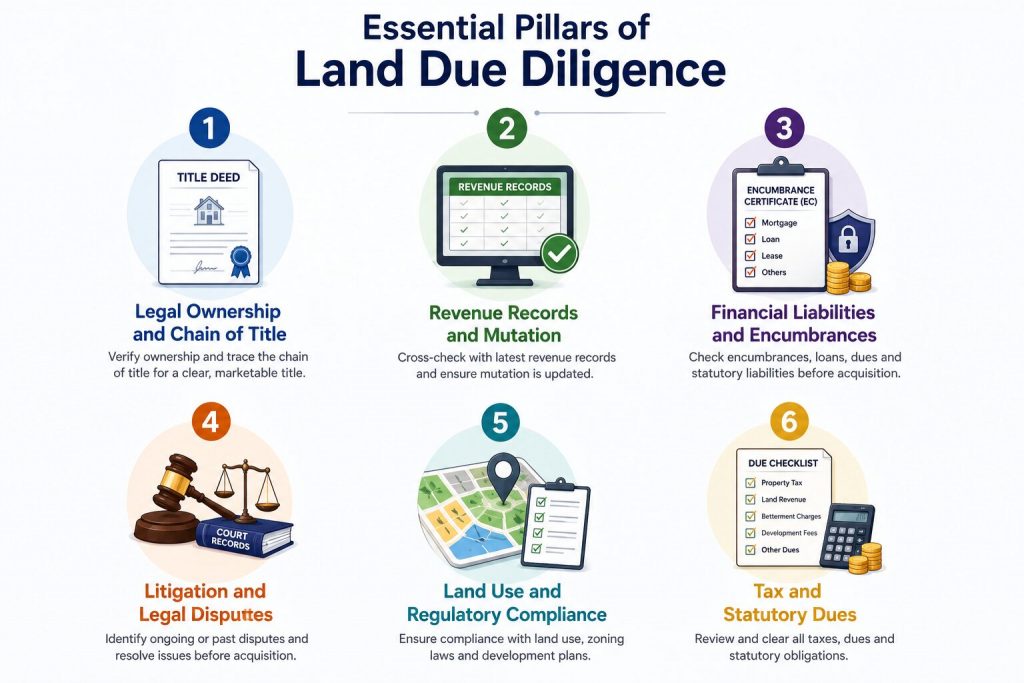
4. Litigation and Legal Disputes
Investigate ongoing and historical disputes involving the land, owners, and related survey numbers. Risks include inheritance and partition claims, boundary disputes, forged documents, tenancy rights, adverse possession, competing ownership claims, government acquisition proceedings, environmental matters, and unauthorized land use.
Review court records, pending civil suits, government notices, and injunctions restricting transfer or development. Resolving issues before acquisition is less costly than defending disputes afterward.
5. Land Use and Regulatory Compliance
Verify that the intended project complies with development plans, zoning, and land-use classifications. Agricultural land may require conversion for industrial or commercial use; green belts, conservation areas, heritage zones, and environmentally sensitive regions may restrict development.
Master plans may reserve land for future highways, industrial corridors, metro rail, or public utilities. Early verification avoids redesigns, approval delays, and legal complications.
6. Tax and Statutory Dues
Review property taxes, land revenue, betterment charges, development fees, and other statutory obligations. Unpaid dues can delay registration, financing, or future approvals. Municipal, Panchayat, and development-authority records should be checked before acquisition.
Leveraging GIS and Spatial Intelligence
Traditional due diligence relies on documents, revenue records, and physical inspections, but modern projects also require geospatial analysis. GIS can overlay cadastral boundaries with satellite imagery, master plans, environmental zones, utility corridors, and government notifications to identify hidden risks.
A legally compliant parcel may still overlap a proposed highway, ecological buffer, utility corridor, flood-prone area, or other restriction. GIS-based analysis can compare survey boundaries with satellite imagery, topography, zoning, flood areas, and transport networks, providing a more complete assessment of development suitability.
For large land portfolios, GIS-based land records management consolidates ownership, cadastral maps, leases, valuation, survey information, and approvals, improving accuracy, collaboration, and due-diligence speed.
Satellite Imagery and Remote Sensing
Multi-temporal, high-resolution satellite imagery helps verify actual land conditions and detect changes not reflected in official records. It can reveal unauthorized construction, encroachments, vegetation changes, waterbody expansion, mining activity, and land-use changes, while historical imagery can indicate whether land was vacant, cultivated, or urbanized.
Integrated with a Digital Land Management System, imagery helps legal, survey, and project teams validate physical conditions with fewer repeated field visits.
Physical Site Inspection
Physical verification remains essential. Site visits confirm whether ground conditions match legal documents, cadastral maps, and satellite imagery. Survey teams verify boundaries, encroachments, access roads, surrounding infrastructure, water bodies, drainage, slopes, and vegetation.
Field teams can also engage local authorities and landowners to identify historical disputes, access rights, and planned infrastructure. GIS-enabled survey tools can link observations directly to maps and centralized project databases.
Environmental and Climate-Related Risks
Environmental due diligence is especially important for infrastructure, manufacturing, mining, and renewable-energy projects. Check wetlands, forests, coastal zones, wildlife habitats, and environmentally sensitive areas.
GIS can overlay parcels with protected areas, flood hazards, seismic zones, drainage networks, and climate-vulnerability datasets. Assess flood risk, erosion, water availability, and extreme-weather exposure to support sustainable and resilient investment decisions.
Infrastructure Planning and RoW Verification
Highways, railways, metro networks, transmission lines, industrial corridors, and urban expansion can affect land value and usability. Verify proposed Right-of-Way (RoW) corridors to avoid land that may later face compulsory acquisition or development restrictions.
Integrating official planning datasets with a land-management solution helps identify parcel overlaps early, reducing redesigns, compensation disputes, and project delays.
How Modern Land Management Software Transforms Due Diligence
Large acquisitions generate legal documents, ownership records, survey reports, GIS layers, valuation data, leases, financial approvals, photographs, and regulatory clearances across different departments. Disconnected systems increase errors, duplication, and missed risks.
Enterprise land-management software centralizes the land lifecycle and supports due diligence, acquisition, ownership management, lease administration, compensation tracking, document management, compliance monitoring, and reporting. For large portfolios, it improves efficiency and reduces legal and financial risk.
Managing the Complete Land Lifecycle
Organizations need systems that support acquisition, allocation, leasing, utilization, and long-term governance—not just document storage. Integrated acquisition platforms manage negotiations, approvals, ownership verification, document workflows, and stakeholder communication.
After acquisition, the platform can function as a Land Records Management System, keeping ownership, cadastral, financial, and regulatory information synchronized. For industrial parks, government agencies, SEZs, and enterprises, Land Allotment and Land Leasing/Lease Management capabilities can support plot allocation, renewals, rent calculations, compliance, and tenant management.
By integrating GIS, legal records, financial information, and workflow automation, enterprise land-management platforms turn fragmented land administration into a connected, data-driven ecosystem.
Common Mistakes in Land Acquisition
- Treating a registered sale deed as sufficient proof of undisputed ownership without checking title history, legal heirs, co-owners, and restrictions.
- Relying only on revenue records without physical inspection, which can miss encroachments, unauthorized construction, boundary shifts, and access issues.
- Ignoring land-use conversion, zoning, environmental restrictions, or proposed infrastructure corridors.
- Managing large volumes of legal, survey, valuation, GIS, and approval information across separate spreadsheets or shared folders, increasing the risk of missed information.
Best Practices for a Reliable Due Diligence Process
Treat due diligence as a multidisciplinary exercise involving legal professionals, surveyors, GIS specialists, planners, finance teams, and project managers. Cross-verify documents with revenue records, planning authorities, cadastral maps, and physical surveys; discrepancies can reveal otherwise hidden issues.
Maintain every verification report, ownership document, approval, survey drawing, photograph, and communication in a centralized repository for audits, financing, and regulatory inspections. Organizations managing multiple projects should use standardized workflows so every acquisition follows consistent quality standards.
The Shift Towards Digital Land Management
Large infrastructure, renewable-energy, manufacturing, industrial-corridor, and urban projects may involve hundreds of survey numbers across districts or states. Spreadsheets, emails, paper records, and disconnected databases make information retrieval, approvals, and reconciliation unnecessarily difficult.
Digital Land Management Systems centralize ownership records, cadastral information, GIS layers, survey reports, financial data, legal documents, approvals, and project milestones. This gives legal, engineering, planning, and management teams a common dataset, improving transparency and reducing duplication.
Beyond Acquisition: Managing Land Throughout Its Lifecycle
Acquisition is only the beginning. Organizations must also manage allocation, leasing, utilization, compliance, maintenance, and long-term asset management. An integrated platform can manage the complete lifecycle of every parcel.
Government agencies and industrial development authorities can use Land Allotment Software for transparent plot allocation and digital approvals. Enterprises with leased assets can use Land Leasing and Land Lease Management capabilities for rent calculations, renewal reminders, compliance, and document management. Integrating these functions helps growing land portfolios remain accurate and operationally efficient.
Why GIS Is the Foundation of Modern Land Management
GIS has become a decision-support tool for acquiring, managing, and developing land. A GIS-based land management system combines legal boundaries with satellite imagery, master plans, utility networks, environmental layers, infrastructure corridors, and administrative boundaries.
Connecting ownership records directly to digital maps makes information easier to access, validate, and update. This is especially valuable for renewable energy, mining, utilities, manufacturing, logistics, telecommunications, and smart-city development, where land decisions depend on both legal and geographic context.
Building a Connected Land Information Ecosystem
The future of land administration is connected digital platforms in which information is linked rather than isolated. A modern Land Information Management System can combine ownership records, cadastral maps, lease agreements, valuation data, approvals, GIS layers, survey information, and supporting documents in one repository.
With Land Records Management capabilities, organizations can maintain histories of ownership changes, mutations, legal documents, and regulatory approvals while keeping information consistent across departments. For large land banks, this improves operational efficiency, governance, audit readiness, and confidence during future acquisitions, financing, and compliance reviews.

Darshana Mukherjee is a Senior Consultant in Business Development with over 11 years of experience in sales, primarily focused on the Geospatial IT industry. Her expertise lies in driving business growth through strategic partnerships, client engagement, and delivering solutions. She combines her technical knowledge with business acumen to contribute effectively to organizational success.
Darshana Mukherjee
Darshana Mukherjee is a Senior Consultant in Business Development with over 11 years of experience in sales, primarily focused on the Geospatial IT industry. Her expertise lies in driving business growth through strategic partnerships, client engagement, and delivering solutions. She combines her technical knowledge with business acumen to contribute effectively to organizational success.


You May Also Like

Land Acquisition Process Made Easy – What Do You Need to Know?

Advantages of AI and GIS-Driven Compensatory Land Allocation System