Project Progress Monitoring System: Revolutionizing Project Management with GIS and MIS
Effective project management is critical to an organization’s success. However, with projects becoming increasingly complex and timelines tighter, traditional methods often fall short. This is where the Project Progress Monitoring System (PPMS) comes in — a GIS and MIS-powered solution designed to streamline operations, enhance collaboration, and keep projects on track from inception to completion.
What is a Project Progress Monitoring System?
A Project Progress Monitoring System is a software platform that leverages Geographic Information System (GIS) and Management Information System (MIS) technologies to provide real-time insights into a project’s progress. It aims to:
- Centralize project information
- Automate monitoring and reporting processes
- Facilitate collaboration among stakeholders
- Identify potential risks and bottlenecks early on
From construction and manufacturing to IT and government projects, PPMS is transforming how organizations manage and execute their projects.
Key Features of a Project Progress Monitoring System
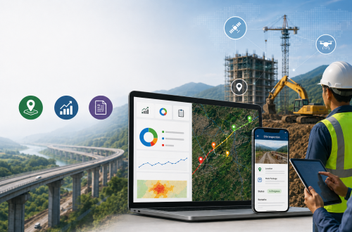
Real-Time Data Integration
PPMS integrates seamlessly with various data sources, including GIS platforms, financial systems, and field devices. This ensures stakeholders always have up-to-date information on the project’s status.
GIS-Driven Analytics
GIS-powered analytics provide predictive insights based on spatial data, helping project managers visualize progress in real time. These insights enable proactive decision-making to avoid delays, resource shortages, or budget overruns.
Interactive Dashboards
Customizable dashboards offer a visual representation of project metrics, such as task completion rates, budget utilization, and spatial data from GIS tools. This feature promotes transparency and accountability.
Automated Reporting
PPMS generates automated, customizable reports that incorporate GIS data and MIS analytics, reducing manual effort and enhancing accuracy. Reports can be tailored for various stakeholders, from team members to executive leadership.
Risk Management
The system utilizes GIS to analyze spatial data and historical trends to identify potential risks and bottlenecks. Alerts are triggered for issues such as delays or resource shortages, allowing teams to address them before they escalate.
Mobile Accessibility
Mobile-friendly interfaces enable project managers and field teams to access and update project data on the go, ensuring constant connectivity and collaboration, even from remote locations.
Benefits of a Project Progress Monitoring System
Enhanced Productivity and Efficiency
By automating repetitive tasks like status updates, reporting, and data analysis, PPMS frees up teams to focus on more strategic activities.
Improved Collaboration
PPMS acts as a centralized hub for all project-related communication, documents, and updates. Team members can collaborate and resolve issues in real-time, with GIS maps and MIS data accessible to everyone.
Accurate Decision-Making
With GIS-driven insights and real-time MIS data, project managers can make informed, data-driven decisions that lead to better project outcomes.
Timely Project Delivery
PPMS offers a comprehensive view of milestones, deadlines, and potential bottlenecks, ensuring projects are completed on time and within budget.
Scalability
PPMS can be tailored to fit projects of varying sizes and complexities, making it a versatile tool for organizations across industries.
Use Cases of Project Progress Monitoring Systems
Construction Industry
Construction projects often involve multiple stakeholders, tight deadlines, and strict compliance requirements. A PPMS can:
- Track on-site progress in real time using GIS maps.
- Monitor budget utilization and expenses through MIS reporting.
- Facilitate communication between contractors, architects, and clients.
IT and Software Development
For agile and DevOps teams, PPMS helps:
- Monitor sprint progress using GIS-based tools for visualizing work allocation and resource use.
- Track resource allocation and generate performance reports using MIS.
- Generate detailed reports for stakeholders.
Government Projects
PPMS is invaluable for large-scale government projects:
- Ensures transparency in public spending with GIS-based tracking and MIS reporting.
- Provides real-time updates to stakeholders.
- Identifies delays and inefficiencies using spatial data and MIS-driven analysis.
Manufacturing
Manufacturers can use PPMS to:
- Track production schedules with GIS-based maps to visualize factory layouts.
- Monitor supply chain performance using MIS tools.
- Predict equipment maintenance needs with data from GIS and MIS systems.
How to Choose the Right Project Progress Monitoring System
When selecting a PPMS, consider the following factors:
Features
- Ensure the software includes essential functionalities such as GIS-powered maps, MIS-driven analytics, automated reporting, and mobile accessibility.
Integration Capabilities
- The system should integrate seamlessly with your existing tools and platforms, particularly GIS and MIS systems.
Scalability
- Choose a solution that can grow as your organization and projects become more complex.
User-Friendliness
- An intuitive interface is crucial for quick adoption and reducing the learning curve.
Vendor Support
- Opt for a vendor that offers comprehensive support, including training, troubleshooting, and regular updates.
Future Trends in Project Progress Monitoring Systems
Advanced GIS Integration
- The future of PPMS lies in more advanced GIS capabilities, such as enhanced spatial data analysis for deeper project insights.
IoT and GIS Synergy
- Integration with IoT devices and GIS will allow real-time tracking of physical assets, enhancing project monitoring and control.
Customization and Flexibility
- Future systems will offer even greater customization options to tailor both GIS features and MIS reports to industry-specific needs.
Blockchain for Transparency
- Blockchain will add an extra layer of transparency, particularly for financial transactions, documentation, and GIS-based records.
Conclusion
A Project Progress Monitoring System (PPMS), powered by GIS and MIS, is more than just a tool; it’s a transformative solution for organizations striving to improve efficiency, transparency, and project outcomes. By integrating spatial data with management information systems, businesses can ensure projects are delivered on time and within budget while fostering collaboration and innovation.
Ready to transform your project management approach? Explore how a tailored PPMS with GIS and MIS integration can meet your organization’s unique needs and set you on the path to success.
This version focuses on GIS and MIS as key drivers for project monitoring, showcasing how spatial and management information can optimize project management processes. Let me know if you’d like any more changes!

Experienced Consultant with a demonstrated history of working in the Information Technology and Services Industry. My role at CyberSWIFT Infotech Pvt. Ltd. is all about building Business Relationships & nurturing them with my ability & trust for growth. My Skills involve Business Communication, Business Analysis, Strategy Formulation & Planning, Understanding Customer Requirements, Providing Geospatial Solutions , Conducting DGPS Survey , Building WebGIS Applications & implementing many more GIS-based smart strategies to cater to the needs of my client.
Aman Prabhakar
Experienced Consultant with a demonstrated history of working in the Information Technology and Services Industry. My role at CyberSWIFT Infotech Pvt. Ltd. is all about building Business Relationships & nurturing them with my ability & trust for growth. My Skills involve Business Communication, Business Analysis, Strategy Formulation & Planning, Understanding Customer Requirements, Providing Geospatial Solutions , Conducting DGPS Survey , Building WebGIS Applications & implementing many more GIS-based smart strategies to cater to the needs of my client.


You May Also Like
GIS-Based Project Progress Monitoring System for Construction & Government Infrastructure Projects
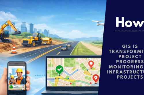
How GIS is Transforming Project Progress Monitoring in Infrastructure Projects