Transforming CGD Infrastructure with GIS Survey & Mapping: From Route Planning to Pipeline Asset Management
In the rapidly expanding City Gas Distribution (CGD) sector, precision planning and reliable asset data are no longer optional—they are critical for safety, regulatory compliance, and operational efficiency. Our specialized GIS Survey and Mapping services deliver end-to-end solutions tailored for CGD projects across India. From corridor mapping of pipeline routes to drone-based leakage detection and GIS- powered asset management systems, we help CGD companies build smarter, safer, and more sustainable gas networks.
Why GIS is Needed in CGD
City Gas Distribution involves laying thousands of kilometers of underground pipelines through congested urban and semi-urban areas while ensuring zero safety incidents and full regulatory compliance.
As The CGD sector involves multiple layers of complexity—from pipeline routing to other underground utility detection for laying and long-term asset management, GIS (Geographic Information System) integrates spatial data, satellite imagery, and field surveys into a single powerful platform helping stakeholders make data-driven decisions throughout the CGD lifecycle.
How GIS Solves Modern CGD Challenges Using GIS Survey Mapping
Modern CGD projects face multiple challenges: dense urban infrastructure, unknown underground utilities, strict ROU (Right of Use) permission norms, environmental clearances, and the need for continuous monitoring of leakage, encroachment, and asset health.
Our GIS Survey and Mapping solutions directly address these pain points:
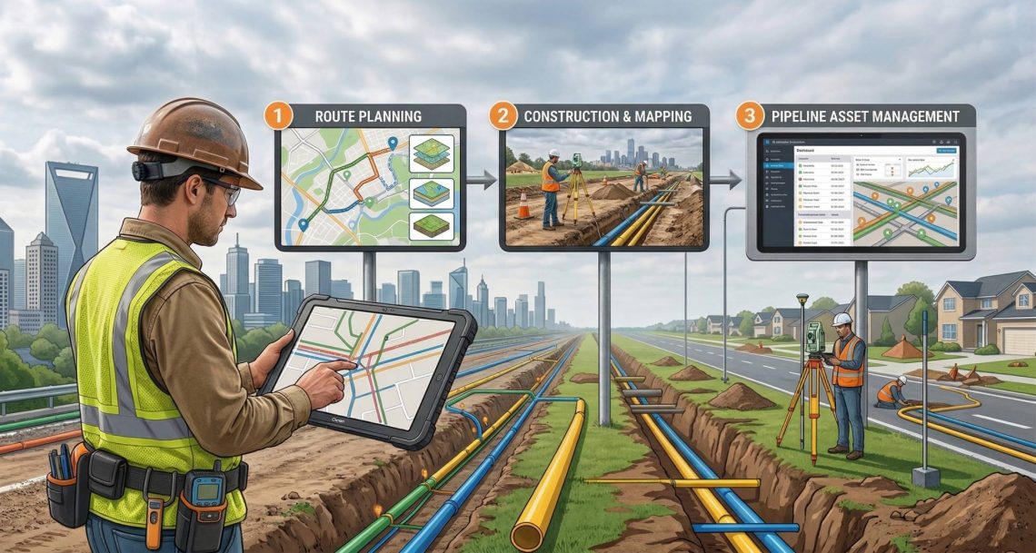
- Accurate Route Planning & Corridor Mapping – Using DGPS/GPS, GPR-based underground utility detection, and drone surveys, we identify the safest and most economical pipeline routes while avoiding existing utilities and sensitive zones.
- Land Use, Land Cover & Soil Analysis – Area-wise Land Use/Land Cover maps and detailed soil surveys with geo-technical investigation ensure stable foundation design and faster statutory approvals.
- Asset Digitization & Real-Time Data Management – We perform underground and overground asset surveys, digitize legacy land base data, and enable new GIS data creation or modification directly from our custom Mobile App with sub meter accuracy.
- Leakage Detection & Encroachment Monitoring – Drone surveys combined with satellite imagery detect pipeline leakage, third-party intrusions, and encroachments in real time.
- Integrated Project Monitoring – We develop custom Pipeline Project Monitoring Systems, GIS- based Dashboards, Land Management Systems, and Mobile Apps for field teams—ensuring every stakeholder has live visibility of current installation GA wise.
Benefits of Using GIS Survey Mapping in CGD
Implementing professional GIS Survey and Mapping delivers measurable ROI for CGD operators:
- Enhanced Safety & Risk Mitigation – Near Real-time leak and encroachment detection plus GPR utility mapping drastically lower the probability of accidents.
- Faster Regulatory Approvals – Detailed AutoCAD drawings, Geo-technical reports, and GIS-based submissions speed up permissions from multiple statutory authorities.
- Improved Operational Efficiency – GIS-powered dashboards and mobile apps enable predictive maintenance, quick incident response, and seamless asset tagging.
- Data-Driven Decision Making – Centralized, accurate GIS data supports long-term network expansion planning and demand forecasting.
- Sustainability – Precise land-use mapping and minimal disturbance to the environment help meet green CGD goals.
Our Comprehensive GIS Expertise for CGD Projects
We offer a complete suite of GIS services specifically engineered for City Gas Distribution:
Route Survey & Corridor Mapping of Pipeline Routes
Detailed topographical surveys, modern route planning techniques, and comprehensive reports before pipeline laying.
Land Use, Soil & Geo-Technical Investigation
Area-wise Land Use/Land Cover mapping and in-depth soil testing for new pipelines and stations.
Underground & Overground Asset Survey + GIS Data Creation
Full digitization of land base data, DGPS/GPS surveys, and GPR-based utility detection.
Drone Survey & Leakage Detection
High-resolution drone surveys for pipeline leakage, encroachment, and intrusion monitoring.
Mobile App & Digital Solutions
Development of Mobile Apps for survey & inspection, near real-time asset tagging, data modification, Pipeline Project Monitoring System and GIS-based Asset Management Systems, Customer Billing & Payment Solution.
Project Support Services
Permission collection from statutory authorities and submission of permission file, required drawing, Maps etc.
Custom Dashboard & Monitoring Systems
End-to-end development of Pipeline Project Monitoring Systems, Land Management Systems, and GIS dashboards.
Real-World Use Cases
Use Case 1: Pipeline Route Optimization in Urban Area
A CGD company used GIS-based corridor mapping to avoid congested zones, reducing project delays by 30% and minimizing disruption.
Use Case 2: Underground Utility Detection Using GPR
During pipeline laying, GPR surveys helped identify existing utilities, preventing costly damages and ensuring safe execution.
Use Case 3: Drone-Based Monitoring for Pipeline Security
Drone surveys enabled real-time detection of encroachments and leakages, improving response time and reducing operational risks.
Use Case 4: GIS-Based Pipeline Project Monitoring Solution, Asset Management System & Customer Billing and Payment Solution
A centralized GIS platform helped manage thousands of pipeline project, improving asset maintenance planning and operational efficiency, better services to customer with billing and online payment solution.
Partner with CyberSWIFT for Next-Generation CGD Infrastructure
At CyberSWIFT, we don’t just provide GIS Survey and Mapping services – we deliver complete digital transformation for City Gas Distribution projects. Whether you are planning a new CGD network, expanding an existing one, or looking to modernize asset management, our expert team is ready to support you with precision technology and proven on-ground experience.


You May Also Like
Enhancing Gas Pipeline Management with GIS: Key Benefits and Applications