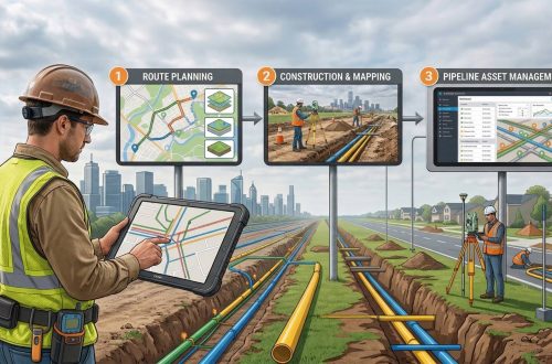
Enhancing Gas Pipeline Management with GIS: Key Benefits and Applications
In the energy and utilities sector, gas pipeline management is complex, requiring precision, safety, and a clear strategy for both existing infrastructure and future expansion. Geographic Information Systems (GIS) have revolutionized pipeline management by providing a spatially accurate, data-rich view of assets. From asset management and leak detection to route planning and demand forecasting, GIS is becoming indispensable for gas companies. This blog delves into the ways GIS transforms gas pipeline management, delivering benefits across safety, efficiency, cost-saving, and planning.
1. Asset Management and Tracking
Asset management is a cornerstone of efficient gas pipeline operations. With GIS, pipeline operators can accurately locate and track each component of the pipeline infrastructure, from main lines to service lines. GIS allows managers to:
- Track Coordinates and Distances: Knowing exact coordinates and distances of pipeline assets enables teams to manage operations, maintenance, and expansion plans more effectively.
- Monitor Pipeline Health Conditions: GIS can store data on material types, ages, and inspection histories, helping identify sections that may need maintenance or replacement.
- Automate Inventory Updates: With GIS tracking, inventory management becomes more efficient and accurate, as any change in asset data is automatically updated across the system.
By providing an interactive map of the pipeline network, GIS reduces the risk of asset loss or misidentification, making it easier to oversee large and complex networks.
2. Enhanced Leak and Incident Management and Response
Safety (HSE) is paramount in gas pipeline operations. GIS supports faster, more effective leak and incident management and response:
- Real-Time Incident Data: GIS helps pinpoint the exact location of leaks or accidents, which enables quicker, data-informed decision-making for emergency teams.
- Efficient Information Sharing: In the event of a leak, GIS allows seamless sharing of real-time data, such as the precise location, affected areas, and surrounding infrastructure, with response teams.
- Risk Analysis and Mitigation: By overlaying GIS maps with environmental, population, and infrastructure data, companies can predict high-risk zones, enabling preventive measures in vulnerable areas.
GIS provides a faster response time by streamlining information flows, ensuring that response teams receive necessary updates promptly, ultimately minimizing potential damage and ensuring community safety and HSE compliances.
3. Consumer Data Mapping and Network Planning
With GIS, companies can maintain a detailed database of consumer information, which is critical for efficient network planning and expansion. GIS enables:
- Consumer Demand Analysis: By mapping consumer locations and usage patterns, GIS helps companies predict areas of higher demand, aiding in expansion planning.
- Identifying Potential Consumers: By overlaying thematic maps, gas companies can identify potential future consumers in specific areas, helping them proactively extend services.
- Pipeline Network Optimization: GIS tools allow planners to visualize existing networks alongside demand hotspots, creating efficient expansion plans with minimal resources and time.
This data-driven approach to network planning supports sustainable growth, allowing for strategic expansion that meets demand without overextending resources.
4. Supporting Design Flexibility and Adaptability
Gas pipeline projects often face unpredictable site conditions. GIS-based pipeline management offers a level of design flexibility that is essential for adapting to real-world variables:
- Automatic Calculations and Adjustments: GIS software can perform calculations related to gas pressure, inlet quantities, and other parameters at all points along the pipeline, ensuring accuracy in the design phase.
- Adjustable Design Models: Teams can manually adjust locations and design specifications within the GIS platform to suit site-specific needs or unexpected obstacles.
- Adaptation for Site-Specific Requirements: GIS provides flexibility in planning around challenging terrains, environmental zones, or densely populated areas, ensuring both safety and regulatory compliance.
This adaptability is invaluable for creating a pipeline network that balances optimal performance with the realities of site-specific constraints.
5. Maintenance and Operations Optimization
For pipeline operators, GIS is a crucial tool in maintaining infrastructure longevity and safety, as it assists in monitoring and addressing potential vulnerabilities. Key maintenance benefits include:
- Identifying Weak Sections for Replacement: GIS enables operators to locate and monitor sections of the pipeline that are susceptible to leaks or degradation, such as segments made of rust-prone materials.
- Implementing Cathodic Protection: GIS can identify sections exposed to environmental conditions that may accelerate rust or corrosion, allowing for the application of cathodic protection or other preventive measures.
- Efficient Resource Allocation: By identifying the most vulnerable or high-risk areas, companies can allocate resources more effectively, focusing maintenance efforts on sections that require it most urgently.
Incorporating GIS into maintenance workflows not only enhances operational efficiency but also prevents costly breakdowns and extends the pipeline’s lifecycle.
6. Cost Savings in Route Optimization
Route optimization is essential in pipeline construction and expansion, as it directly impacts both capital expenditure and long-term operational costs. GIS facilitates cost-effective route planning by:
- Optimizing DPRS Locations: GIS helps in determining the optimal location for District Pressure Regulating Stations (DPRS), which minimizes operational costs.
- Minimizing Route Length: GIS route optimization tools allow planners to create routes that cover maximum reach with minimum length, reducing construction costs and material usage.
- Maximizing Coverage and Efficiency: By critically analyzing network size and pressure requirements, GIS can ensure balanced pipeline sizing, avoiding over- or under-sizing which can lead to inefficiencies and increased costs.
With GIS, gas companies can achieve substantial cost savings while maximizing network efficiency and ensuring consistent supply pressure.
7. Streamlined Network Design and Planning
Planning an efficient gas pipeline network requires careful attention to the balance of supply and demand. GIS provides gas pipeline planners with:
- Rapid Design Adjustments: GIS reduces network design time by allowing for rapid adjustments and simulations.
- Balancing Supply Pressure Across Points: GIS tools can design networks to maintain steady pressure levels at all nodes, avoiding pressure drops or overloads at consumer and intermediate points.
- Detailed Design Parameters and Documentation: GIS-generated maps and Bills of Materials (BoM) document the design parameters at each node, providing a clear record of the network design for ongoing maintenance and future upgrades.
With the ability to create detailed, well-documented designs, GIS simplifies the design process, supporting a streamlined and resilient pipeline network.
Conclusion
The use of GIS in gas pipeline management offers a comprehensive solution for addressing the industry’s most pressing challenges. From ensuring safety through efficient leak management and asset tracking to streamlining network design and achieving cost savings, GIS has become a vital tool in optimizing pipeline operations.
With its ability to support data-driven decision-making, GIS not only enhances operational efficiency but also empowers companies to expand their services sustainably and responsibly. In an industry where precision, safety, and adaptability are paramount, GIS is driving the future of gas pipeline management, making it easier for companies to deliver reliable energy resources to consumers while minimizing environmental impact and operational costs.

Having experience in the Geospatial Industry for more than a decade, deep domain knowledge of the GIS industry & extensive networking capacity, he is managing Power, Water & CGD Accounts Geospatial business with Government, PSU & Corporates. As an SBU manager at CyberSWIFT, Malay works closely with the Utility department Pan India with department leaders, and end-users to tailor GIS technology & GeoSpatial Solutions. He holds a GIS degree from Jadavpur University, Kolkata.
Malay Biswas
Having experience in the Geospatial Industry for more than a decade, deep domain knowledge of the GIS industry & extensive networking capacity, he is managing Power, Water & CGD Accounts Geospatial business with Government, PSU & Corporates. As an SBU manager at CyberSWIFT, Malay works closely with the Utility department Pan India with department leaders, and end-users to tailor GIS technology & GeoSpatial Solutions. He holds a GIS degree from Jadavpur University, Kolkata.


You May Also Like
Addressing Challenges in Oil and Natural Gas Industry with GIS-Based Solutions