CyberSWIFT

Solutions With Innovative Future Technology

CyberSWIFT
  • GIS-based Project Monitoring System Help in Road Construction Management
    GIS,  Project Progress Monitoring System,  Urban Development

    How Does a GIS-based Project Monitoring System Help in Road Construction Management?

    7th August 2023 / 0 Comments

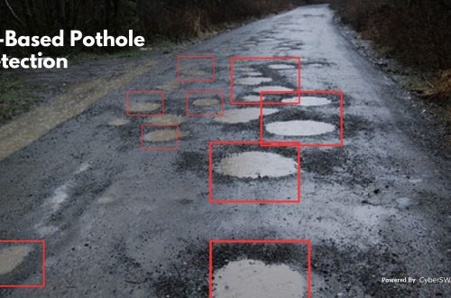
    A GIS (Geographic Information System) based project monitoring software can significantly enhance road construction monitoring management by leveraging geospatial data and analysis. Here are some ways in which GIS-based software helps in road construction management: Site Selection and Planning: GIS allows project managers to analyze various geographical factors such as terrain, soil types, land use, and environmental considerations. This aids in selecting suitable road construction sites and optimizing the project’s route and alignment. Data Integration: GIS-based software can integrate various data sources, including satellite imagery, drone surveys, LiDAR data, and ground-level data, into a single platform. This comprehensive dataset provides a holistic view of the project area and assists in…

    read more
    Dip Mitra

    You May Also Like

    Case Study of Samiksha - an ambitious e-Governance initiative of PWD West Bengal

    Case Study of Samiksha – an ambitious e-Governance initiative of PWD West Bengal

    21st October 2021
    agriculture land with map pin to define the land area

    Revolutionizing Land Management with Land Information Management Systems

    30th March 2023
    corporate social responsibility software by techcsr

    Geo-Targeting Goodness: The Synergy Between GIS and Corporate Social Responsibility

    14th August 2024
  • GIS,  Project Progress Monitoring System

    Top 10 Benefits of a GIS-Based Project Monitoring System

    27th January 2023 / 0 Comments

    What is a Project Monitoring System?  A GIS-based project monitoring system uses geographic information systems (GIS) technology to track and manage the progress of a project. This type of system allows users to view and analyze project data in a geographic context, such as mapping project locations and displaying information about project milestones and timelines. It also allows users to share the data with other stakeholders in a project, such as project managers, engineers, and government officials. This system can be used for a wide range of projects, including infrastructure development, natural resource management, and urban planning. Benefits of Using a Project Monitoring System: 1. Spatial Visualization: GIS-based project monitoring systems allow…

    read more
    Dip Mitra

    You May Also Like

    land and litigation management software

    Manage Land-related Legal Disputes Through the Legal & Court Case Management Module on LAMS

    12th September 2023
    GIS-based Project Monitoring System Help in Road Construction Management

    How Does a GIS-based Project Monitoring System Help in Road Construction Management?

    7th August 2023
    Case Study of Samiksha - an ambitious e-Governance initiative of PWD West Bengal

    Case Study of Samiksha – an ambitious e-Governance initiative of PWD West Bengal

    21st October 2021

Back to site

RECENT POSTS

  • transforming forest management through digital innovationTransforming Forest Management Through Digital Innovation
  • transforming power distribution through gis-based survey and mapping solutionsTransforming Power Distribution Through GIS-Based Survey & Mapping Solutions
  • gis-based project progress monitoring system for construction government infrastructure projectsGIS-Based Project Progress Monitoring System for Construction & Government Infrastructure Projects
  • gis property mapping survey and qr-based uid system for municipal governanceGIS Property Mapping Survey and QR-Based UID System for Municipal Governance: A Complete Digital Transformation Framework

Categories

  • Artificial Intelligence
  • CSR
  • Forest Management
  • GIS
    • Disaster Management
  • Healthcare
  • Hoarding Management
  • LAMS
  • Land
  • Oil and Gas
  • Power Utility
  • Project Monitoring
  • Property Survey
  • RCMS
  • Remote Sensing
  • Retail
  • Salesforce
  • Telecom Utility
  • Uncategorised
    • Project Progress Monitoring System
  • Urban Development
  • Utility
  • Water Utility Solution
Copyright © 1997-2026 CyberSWIFT® Infotech Pvt. Ltd.
Ashe Theme by WP Royal.